
Jugal-A New Destination
Tourism industry is a sector that holds a lot of potential, the progress and development of many nations who have invested in the development of their respective tourism industries is apparent to everyone. In the current times, the tourism industry is considered as one of the most important industries of the world. Tourism is a source of not only recreation and enjoyment, but it also is a medium towards a nation's economic development and international diplomacy, peace, and harmony.
It also comparatively produces less pollution than other industries, and as such its significance is being recognized more and more each passing day. Among the many tourism destinations of the world, our country Nepal is one of them, and Sindhupalchok, one of the 77 districts in the country, holds a lot of possibilities when it comes to tourism. The district holds religious, spiritual, historical, cultural, geographical, economic and natural significance.
The closest mountain range to the city of Kathmandu- the Jugal Mountain Range; Nepal's oldest tourism pathway Helambu; ranked no 7 in the list of the world's top destinations for water adventure and for bungee jumping-the Bhotekoshi River; the religiously and naturally important BhairabKunda and Panchpokhari, along with historically significant DugunaGadhi fort etc are some of the most important tourism sites of the district. Among these destinations, in the recent times, the JugalMountain Range and its surrounding regions are becoming the most sought out destinations for tourists.
The Jugal Mountain Range
In the 1930's, British mountaineer Bill Tilman, who was doing a research on the many mountains of the Nepalese Himalayas, passed through the Jugal Mountain Range and its Basecamp, Panchpokhari and what is known today as the Tilman Pass. He published his findings in the book "Nepal Himalaya", and after reading said book, in 1955, three American women decided on a journey to summit the peaks in the Jugal Mountain Range. Guide Gyalzen Sherpa was a part of the climbing team.
Because of high altitude, one of the members couldn't make it to the summit and had to stay below, while the rest trudged on but unfortunately, they could only reach halfway because of bad weather. At the time, the peak was named Gyalzen Peak. The Jugal Mountain Range is 145km from the capital city of Kathmandu, and encompasses 11 mountains over the altitude of 6000m above sea level. Despite being in close proximity to the capital city and holding a lot of potential in terms of trekking and mountaineering, tourism activities in this region stayed stagnant for six decades.
The peaks in the Jugal Mountain Range:
- BhairabTakura (6799m)
- DorjeLakpa (6966m)
- Gangchhembu (6378m)
- Guru KarpoRi (6889m)
- Gyalzen Peak (6151m)
- Langshisa Ri (6412m)
- Lempu Gang (6079m)
- Lempu Gang East (6735m)
- FurbaGhechyu (6637m)
- UrkenMang (6143m)
- Yangri (Jugal) (6535m)
The First Ascent
Although the peaks in the Jugal Mountain Range have been open for climbing as permitted by the Government of Nepal since many years ago, until 2075 BS, the mountains hadn't been summited yet. The tourism industry is a major industry of Nepal and yet despite the range lying so very close to Kathmandu, the fact that none of the mountains were summited remains a mystery.
The range, with its many mountains of different heights, lies in the Jugal Rural Municipality in the district of Sindhupalchok, a district adjoining the district of Kathmandu. Making it feasible and easier for climbers to climb the mountains in this region would aid to the development of the region as a tourism destination which would in turn uplift the living standard of the local people, who despite living in a district adjacent to Kathmandu, live below the poverty line.
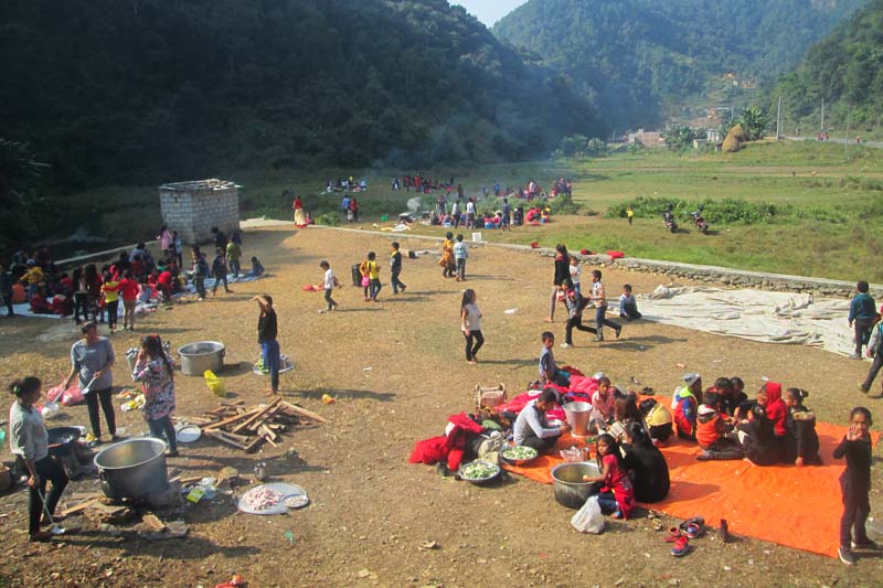
Tourism is one of the major sectors that can help bring about a drastic change in the livelihood of the people in the district, and with this in mind, for the first time in the history of mountaineering in Nepal, the government itself actively set out on a campaign to involve Nepalese mountaineers in the first ever ascent of the peaks in the mountain range, which marks an important point in history of mountaineering in Nepal.
With benefits such as less stress, less distance and less costs, this region is certain to attract mountaineers and mountain lovers in the near future, and for this reason, the Bagmati Provincial Government organized a team of 7 Nepalese mountaineers who successfully summited the peak on the 26th of Chaitra, 2075.
The first Via Ferrata in Nepal
The Via Ferrata has been built for the first time in Nepal for the purpose of traversing on a challenging and adventurous pathway. The Via Ferrata was constructed to make it easier to get to the peaks of several mountains in the Jugal Mountain Range. Especially in Europe and the Americas, Via Ferrata is sought out for adventure.
Among the 11 peaks in the Jugal Mountain Range, 6 of them have to be reached through NgyangKharka Basecamp which lies at the height of 4720m above sea level and the 80 m long Via Ferrata was constructed to make the path to the Basecamp easier. To ensure the safety of the visitors, it is mandatory for climbers to take appropriate safety equipment with them and to follow necessary safety procedures, as well as be accompanied by an experienced guide.

Religious significance of Ne-pemasal :
Nepemasal is a hidden gem identified as a spiritual energy center in the Holy Tripitak, situated in the laps of Jugal Himalayan Range in Sindhupalchok district. It is about 125 kilometers from the northern region of Kathmandu. After crossing the last village named Dippu in the Jugal Rural Municipality, it takes about one day to trek to Nepemasal.
After trekking along the river-side you come along forests, meadows and bridges until arriving at a clearing. The warm opening with a stream and meadows is Nepemasal. Jugal mountain range shines like silver on the northern sky while forests lay close in complete wilderness on all sides. Because of the river and vegetation, visitors can easily spend time at this place. In fact, there is a cave and numerous smaller stone pockets which provide shelter from rain and sunshine.
A few deep practitioners of meditation make special trip to this place to dive into their spiritual practice in solitude at this place. It is not a well-known place but highly revered by those who are aware of it.
The legend says that Guru Rinphoche, also known as Padmasambhava, stopped for mediation at this place in ancient times. Nepemasal is considered a holy site by both Hindu and Buddhist practitioners.
The name originates from "Ne" meaning pilgrimage, Pema meaning lotus-like, and chhalmeaning painted in white. Nepemasal is a place that looks like a white-lotus-shaped pilgrim valley. Except for the festival of Buddha Purnima, the region remains mostly untouched by human activity. This complete wilderness region is lush with colorful flowers and even the stones wear various shades.
[caption id="attachment_23516" align="alignnone" width="990"] Jugal Himal[/caption]
In some ancient texts and folklore it is believed that is Nepemasalis one of the top ten best holy sites in the world. It is believed that Lord Buddha said that someone special will take birth to continue his work in the future. Four hundred years after his Nirvana, in the 8th century, Guru Rinpochhe was born in the state of Odissha in India.
He walked through this region over many years taking shelter in caves, spreading wisdom for the liberation of sentient beings of the planet. He is believed to have reached Pharping, KhotangHalesi, Rasuwa among other places and he reached is Nepemasal through Helambu. He spent a long time here along with Bajrayogini.
According to folklore, the powerful ruler DechenGyalmo reigned in the region with a large army and was considered a saitan that relished human and animal flesh. It is said that it was very difficult to change DechenGyalmo’sprinciples. Ultimately, Guru Rinpoche was able to win the war but instead of punishing them, he compassionately designated twelve sisters of DechenGyalmo to be the guards of the holy region.
He named the sisters as ‘Sungma’ and appointed them to protect various Buddhist texts. Local people believe the Sungma sisters still provide protection to the place even today. That’s why when people visit the place they are recommended to recite the Tati GyalmoSungma chant. Guru Rinpoche developed several heritages in the region and kept various Buddhist texts and sutras in this place. La GangenDorjeLhakpa is believed to have been around during this time, it is after him the beautiful triangular mountain in the Jugal range is named DorjeLakpa. La WangbuGyachane, or Lord Shiva descended to meet Guru Rinpoche at the time and left Hindu sutras.
The cave present in the area is where Guru Rinpoche is believed to have performed JillapDupsi himself. There are stone relics that resemble incense holder, and utensils which were used by the Guru.
He has left clear instructions on the kind of worshipping and chanting people need to perform in order to see with their own eyes the valuables relics and wildlife of his time. Instructions also exist on how to enter gateways from all four directions. The legends say that on his way back to Tibet Guru Rinpoche himself told about Nepemasal to KhadoHiseChhogel, Fa Gong Birochana, and ChyogyalThisongDeuchen.
He made predictions about the world events and mentioned that only is Nepemasalwill remain at the end of final global destruction. These stories can be found in sutras in Buddhist scriptures.
While the ancient legends are mesmerizing what is even more surprising is that lamas and serious meditation practitioners visit this place for spiritual hibernation in modern times as well. Although few people know about it, the place carries spiritual significance of great measure. Fortunately, in the year 2019, one of the virgin mountains in the Jugal range, Mt Gyalzen was climbed for the first time.
The trek to Jugal Base Camp passes through is Nepemasal. This has opened doors of hope for the economic prosperity of the people in the region who have lived under poverty for many generations. While development and prosperity is important, it is also pertinent to protect the spiritual significance, cultural heritage and environmental integrity of the place. Hence, the local people, government and well-wishers, are developing plans for the holistic development of the region.

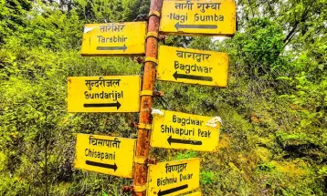
How to get there?
Day-1: Drive to Kyansing Village (2520m) 112km, about 7-8 Hours
Accommodation: Home stay
Kyansing is all Sherpa Village with pure Sherpa culture about 150 Houses, some stupas and Mani wall.
Day-2: Trek toDippu Village 2300 m, about 6-7 hour walking
Accommodation: Home stay. Dippu is last village in this trip, total 8 houses of Sherpa communities.
Day- 3: Trek to Ne-Pemasal (3470m.) 11km-7 hours (N28’05’50.5” -E085’48’29.6”)
Accommodation: Mountain hut/Tent
Ne-Pemasal is a very beautiful open valley and is considered a very sacred pilgrimage and meditation place where Padmasambhava is believed to have meditated in the 8th century by the Buddhists.
Day-4: Rest and Acclimatize.
A steep 2 & ½ hours uphill hike to Bumbasherku 4200m/13775ft. You can also camp here and there is a small cave near the camp site which can accommodate about 6-7 people. This cave is also known as a meditation cave.
Day-5: Trek to Bumbasherbu-Basecamp (Yang Kharka) 4700m 6-7 Hours (N 28.08’05.1” – E 085.50’08.1”)
From Bumbasherpu after one hour walk you have to descent down about 250m to the end of Jugal Glacier, the condition of the walk will depend on the condition of the snow. You may need fixed line or Rope up incase of heavy snow. And after crossing the Jugal Glacier climb the Via Ferrata (Iron way). High Camp (NyangKharka) is a very beautiful and safe place between Phurbaghechyu Glacier, Jugal and Yangri peak Glacier. You can climb the entire mountains like Phurbaghechyu (6637mtr), Yangri (Jugal) Peak (6535mtr), Gyalzen peak (6535mtr, DorjeLakpa (6966mtr.)
Day-6: Rest & Acclimatize.
Day-7: Head to Camp-I 5180m/16990ft. 3-4 hours (N 28.10’08.6” – E 085.50’38.6”)
Day-8: Summit (N 28.11’01.5” – E 085.50’16.1”) and back to High Camp (NgyangKharka)
From Camp-I you can start at 3 am than will get on the top at 10 AM.
If 1st wall and summit head wall is icy then you may need to fix the fixed rope around 500 m Rope. If you find many crevasses from Camp I then Rope up is a must requisite.
Day-9: Base camp (NgyangKharka)
Day-10: Wrap up camp and trek back to Ne Pemasal
Day-11: Trek from Ne-Pemasal to Tembathang
Day-12: Trek fromThembathang to Gumba Village, about 3 hours and drive back on the same day to Kathmandu.
You Might Also Like


Comment / Rely From